Difference between revisions of "Horizontal Situation Indicator MFD"
(HSI MFD.) |
m (Arvil moved page User:Arvil/Sandbox01 to Horizontal Situation Indicator MFD: Move to article page.) |
(No difference)
| |
Latest revision as of 12:25, 9 December 2024
HSI, horizontal situation indicator MFD mode, is used to navigate and align with a runway at a spaceport, and to follow the proper glideslope for landing, or to align with a VOR transmitter to achieve a desired heading relative to the VOR. HSI is similar to aircraft instrument navigation systems.
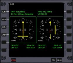
HSI consists of two displays, left and right. Each can be slaved to a COMNAV frequency NAV 1, 2, 3, or 3 as indicated at the top of each display and the frequency programmed. Just below that is what that frequency is used for near your location. Inside the green square is a gyrocompass indicating the ship's current heading at the top, the compass rotates as the heading changes. The yellow arrow is the Omni Bearing Selector (OBS) or course arrow. The center of arrow is the Course Deviation Indicator (CDI), which will deflect left or right if your course is off the desired path. The CDI can be adjusted to program the desired heading. On the lower left is the word 'TO' or 'FROM' indicating whether you are heading toward or away from the VOR beacon. When the display is programmed to an ILS beacon, there is a horizontal yellow bar to indicate whether you are above or below the glideslope approaching the runway.
At the bottom are current course (CRS) (ship's heading), bearing to the transmitter (BRG); deviation (DEV)(how far off center you are), and distance (DST) from you to the transmitter. So, the in the image shown, the left instrument indicates that the ship's heading is 330°, the bearing to the transmitter is 150° directly behind, deviation is zero, ship is centered on the beacon, and distance is 282.7 meters. The right display shows a course of 330°, bearing to the VOR is 142° behind and to the right, deviation is 08°, the ship needs to rudder right, and distance is 22.99 km.
So, in the image showing the HSI MFD display, the left display indicates that it is tuned to 134.20 MHz, which is the ILS for Runway 33 at Cape Canaveral. The ship is heading 330° as indicated by the 33 at the top. The arrow and CDI indicates the ship is on the correct heading for final approach. The center of the arrow is aligned with the arrow indicating that the ship is aligned with the desired heading and it is lined up to the runway. The horizontal glideslope bar is below center indicating that the ship is above the glideslope and it should descend until the bar is centered vertically. The 'FROM' in the lower left indicates that the ship is past the beacon and is heading away from it. Actually, this screenshot was taken with the DG on the runway at takeoff position which places it past the glideslope path. So, to correct for flight path, if the CDI of the arrow is to the left of the arrow, rudder left to move toward the correct flight path, and likewise if the CDI is to the right, rudder right. If the glideslope bar is below center, descend, if above center, ascend or level out until the ship meets the glideslope.
The right display in the image is programmed to NAV 2, 112.70 MHz, the VOR for KSCX. The ship is heading at 330°, has past the VOR transmitter as indicated by the FROM. The ship is on the correct heading but the beacon is to the right of the ship, so a right rudder is needed to meet the beacon.
If the arrow is pointing at some heading and you need to approach the ILS for runway 33, Use the OB- and OB+ buttons to rotate the arrow to heading 330°. the CDI will then move left or right of the arrow indicating that you are off the flight path, then you would rudder to move left or right until the CDI is centered.
HSI controls[edit]
- Button L/R (Shift+F) Switch focus to left or right HSI instrument display
- Button NAV (Shift+N) Select NAV receiver (1, 2, 3, 4)
- Button OB- (Shift)+[ Rotate the OBS to the left
- Button OB+ (Shift+]) Rotate the OBS to the right
HSI operation[edit]
To use HSI for navigation:
- Determine frequencies needed by consulting the Object Info and Map menu items in Orbiter, tune a NAV receiver to that frequency.
- Slave an HSI display to that NAV receiver.
- Turn the OBS indicator until the CDI aligns with the arrow and the TO/FROM says TO to fly toward the transmitter, or FROM to fly directly away from the transmitter.
- Turn the vessel until the arrow points to 12 o'clock.
If the CDI goes off center, fly slightly in the same direction to bring it back to center.
For ILS landing at a runway
- This works only for runways that have an ILS transmitter at the approach path.
- Lookup the frequency for the ILS in the spaceport information dialog, tune one of the NAV receivers to that frequency.
- Slave an HSI display to that NAV receiver.
- Once the ship comes within range of the ILS, the arrow will turn to the direction of the transmitter, the OBS will indicate that the beam is to the left or right, and the glideslope indicator will indicate whether you are above or below the proper glideslope. Fly left or right, ascend or descend until both bars are centered and the arrow is pointing to top dead center, then you are on the proper approach path and glideslope.
