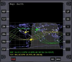
Map MFD
Jump to navigation
Jump to search
Map MFD mode shows the surface map of any body in a cylindrical projection (longitude v. latitude, north up), with the track of the spacecraft, and, if selected at target object.
Features
- Ground track or orbital plane display
- Ground track display: The map shows the planet with the past ground track and future predicted ground paths up to three orbits.
- Orbital plane display: Shows the map with only the current orbital plane of the spacecraft and target.
- Horizon line: Shows where the horizon is from the viewpoint of the vessel, what you can see out your window. Looks like a odd-shaped circle surrounding your ship.
- Track mode: The map of the planet can be scrolled manually or set to follow the ship in the center automatically scrolling the map.
- Terminator Line: A curved line on the map showing the areas of the body which are in daytime and areas are in nighttime. The daylight areas are shaded lighter than the night side.
- Vector coast and contour lines, on the Earth they show land masses, on other bodies topological contour lines.
- Zoom: Zoom the map in or out from 1 to 128 increments of 2n.
- Surface bases and navigation transmitters: Displays the position of VOR transmitters and surface bases, can be turned off or on.
- Surface features: Earth cities and geological features on all bodies with features defined can be turned on.
- Configuration page:Map MFD can be configured by one or more .cfg files.
Buttons and Hot keys
- DSP Shift+D: Switches display to parameter selection page, menu to turn parameters on or off.
- TRK Shift+K: Switch between automatic vessel track mode or static body with moving vessel.
- REF Shift+R: Open an input box to select reference body.
- TGT Shift+T: Open a menu to select a target body or vessel.
- ZM- Shift+X: Zoom out by a factor of 2 down to 1× (global view).
- ZM+ Shift+Z: Zoom in by a factor of 2 up to 128×.

