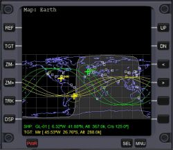
Map MFD
Jump to navigation
Jump to search
Map MFD mode shows the surface map of any body in a cylindrical projection (longitude v. latitude, north up), with the track of the spacecraft, and, if selected at target object.
Features
- Ground track or orbital plane display
- Ground track display: The map shows the planet with the past ground track and future predicted ground paths up to three orbits.
- Orbital plane display: Shows the map with only the current orbital plane of the spacecraft and target.
- Horizon line: Shows where the horizon is from the viewpoint of the vessel, what you can see out your window. Looks like a odd-shaped circle surrounding your ship.
Track mode: The map of the planet can be scrolled manually or set to follow the ship in the center automatically scrolling the map.

