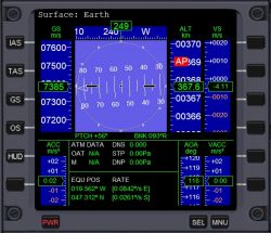
Surface MFD
Jump to navigation
Jump to search
Surface MFD mode is used to assist the pilot in flight close to the surface of a planet or other body. It refreshes at 4Hz unless the user selects a higher rate in the Launchpad dialog, then it refreshes at that rate.
Elements include:
- Artificial horizon with pitch and bank
- Heading indicator tape
- Altitude tape including pherihel and aphel altitude
- Vertical speed tape
- Speed tape, indicated air speed, true air speed, ground speed, or orbital speed
- Acceleration tape
- Angle of Attack (AOA) tape
- Atmospheric data
- Equatorial position, longitude, latitude, rate of change
- Outside air temperature
- Mach number
- Atmospheric density
- Static pressure
- Dynamic pressure
Buttons and Hot keys[edit]
- IAS button or Shift+I: To select Indicated air speed
- TAS button or Shift+T: To select True air speed
- GS button or Shift+G: To select Ground air speed
- OS button or Shift+O: To select Orbital speed
- HUD button or H: To slave the HUD to Surface MFD display
Display components[edit]
- Reference planet: At the top left, it says 'Surface:' followed by the name of the body. Surface will always select the body with the highest percent of gravity acting on the vessel, you can't change it.
- Artificial horizon: The square in the upper part of the display near center. Just like on an aircraft, it shows your orientation with respect to the ground. In straight and level flight, the upper part will display blue to indicate the sky and the lower part will display brown to indicate the ground with a white line in between. As you bank and ascend/descend, it will rotate to indicate your orientation. A series of short white lines is the pitch ladder, whether you are nose up or down. At the pitch ladder. Above the horizon in the blue is a small triangle pointing up indicates your bank angle. The -•- in the center indicates your nose and wings. There is a series of small white squares along the edges of the AH in 30° increments for your convenience in banking angles.
- Along the left side of the display, the upper tape is vessel speed.
- TAS: True air speed, aircraft speed realtive to the surrounding atmosphere as long as the atmospheric pressure p1>10-4 Pa. Less than that the tape reads 0 and the readout is"----".
- IAS: Indicated air speed, air speed calibrated to the density of the atmosphere and speed of sound at sea level. At low flight levels, TAS and IAS may be similar, but, at high altitudes, they will diverge where IAS is less than TAS. This also does not work below 10-4 Pa.
- GS:Ground relative speed, speed relative to the ground taking into account the rotation rate of the planet.
- OS:Orbital speed, speed of the vessel relative to the center of the planet not taking into account the planet's rotation, even if the vessel is landed, OS will show a nonzero since the planet is usually rotating.
- Heading tape: Above the artificial horizon, a "tape" graduated in degrees with a digital display to indicate your heading with respect to true north.
- ACC: Acceleration tape, lower left of Surface MFD display indicates how fast you are accelerating or decelerating.
- ALT: Altitude tape, to the right of the artificial horizon, indicates altitude above ground in km, and has indicators in red for altitude of apoapsis and periapsis.
- VSI: Vertical speed indicator tape, indicates how fast you are ascending or descending in meters per second.
- AOA: Angle of attack in degrees, lower right, second from the right edge, indicates your nose angle up or down with respect to your flight path.
- VACC: Vertical acceleration tape, lower right in the display, indicates how fast your vertical speed is acceleration or decelerating.
- ATM DATA: Atmospheric data, below the artificial horizon.
- OAT: Outside air temperature in Kelvins.
- M:Mach number, speed of sound = 1.
- DNS: Atmospheric density, [kg m-3]
- STP: Atmospheric static pressure (Pa).
- DNP: Dynamic pressure (Pa).
- EQU POS and RATE: Equatorial position, longitude in degrees east or west, latitude in degrees north or south, and the rate of change of each.
See also[edit]
Surface MFD mode in Orbiter.pdf

